|
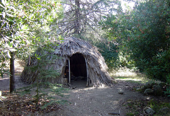
A reproduction of a Tongva hut exhibited at the Franklin Canyon outdoor
teaching facility.
Early Canyon History
Edited by Rick Seireeni
Our community enjoys a rich and complicated history. With a stage set
by geology, topography and climate, successive waves of inhabitants have
shaped and reshaped the community we know as Laurel Canyon
Native
Americans
Arrival of the Spanish
Early Development
Native
Americans
Despite the fact that historians believe some of the largest
concentrations of Native Americans lived along the Southern California
coast, there is little evidence that touches our daily lives.
"And when the last Red Man shall have perished, and the memory of
my tribe shall have become a myth among the White Men, these shores will
swarm with the invisible dead of my tribe, and when your children's children
think themselves alone in the field, the store, the shop, upon the highway,
or in the silence of the pathless woods, they will not be alone. At night
when the streets of your cities and villages are silent and you think
them deserted, they will throng with the returning hosts that once filled
them and still love this beautiful land."
-
Chief Seattle, 1854
Inspite
of these prophetic words, we have little to cement our lives with those
who lived before us for over 40,000 years. The reason is that few Native
Los Angelinos survived the arrival of the Spanish and the subsequent conquest
of the Americans.
The tribes that occupied the LA area when the Spanish arrived were the
Chumash and the Tongva (later called the Gabrielino), the Chumash being
the older and more numerous. While similar, they spoke different languages.
The Chumash were a seafaring people and lived along the coast north of
Malibu. The Tongva lived in small settlements throughout LA and northern
Orange couny, with a substantial settlement at Cahuenga Pass.
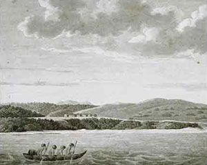
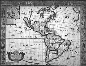
An etching from the 1700's showing coastal California Native Americans,
and a Spanish map showing California as an island.
In the
Hollywood area, it is believed that the Tongva lived at the base of the
canyons. For instance, Dr. Allan E. Edwards of UCLA suggests that a community
of more than 200 lived at the junction of Franklin and Coldwater canyons.
This gave them year-long access to fresh flowing water without being too
far from the marshy flood plain - the vast cienegas that filled the flatland
between Baldwin Hill and Beverly Hills. These marshes, which they navigated
in reed canoes, contained a rich supply of the plants and animals that
sustained them. With a little imagination, we can picture a Tongva settlement
with reed huts and a communal sweathouse near a little stream at the site
of the Chevron station at Sunset and Laurel Canyon Boulevard.
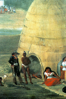
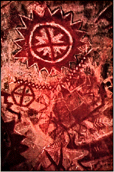 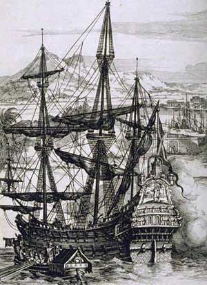
Tongva hut made of reeds laid over a pole frame,an example of Chumash
cave paintings, and a galleon of the type that brought the first Spanish
explorers.
The Tongva grew no crops and did not need to. Food was abundant, the weather
was mild, and as a result, they were able to support a relatively sophisticated
culture. However, these people rapidly fell into decline with arrival
of the Spanish and their mission system, which was essentially agricultural
slave labor.
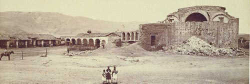
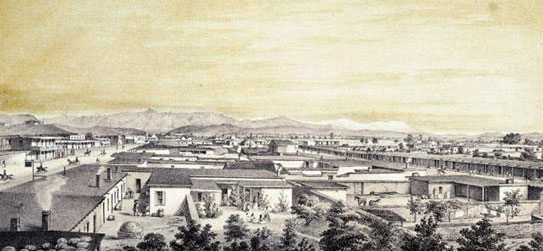
A
typical Spanish mission where Native Americans were confined to slave
labor.
The people
were converted and forced to live in confined areas where they worked
on vast farms. The name Gabrielino derives from their later association
with the Mission San Gabriel. For more on the Tongva, please visit amara@adelphia.net
and http://www.paccd.cc.ca.us/classes/envsci/lariverproj/Indians.htm.
Arrival of the Spanish
The history of the Spanish dates back to 1542, when Juan Rodriquez Cabrillo
anchored off San Pedro. But Spanish settlement did not begin until 1769
when Captain Gaspar di Portola led the only successful expedition sent
by the Spanish Government in Mexico. Portola guessed correctly that the
land would be very productive for agriculture, and as a result, many large
ranchos were established by Mexican settlers. One of Portola's scouts,
Juan Valdez, was among the first to settle, having returned with his family
from Sonora twelve years after the expedition. He founded the Rancho Rodeo
de las Aguas at what is now Sunset and Alpine Drive in Beverly HIlls.
The nearby Hollywood area was divided by other Mexican families between
Rancho La Brea and Rancho Los Feliz. They raised cattle and grew crops
ranging from hay to bananas, pineapples and citrus, and there were even
a few wineries in the area. But life was difficult. Lawlessness was the
mode of the day, and property rights were only as strong as the land owner
who enforced them.
Nevertheless,
one windfall for these early ranchers was an unusually strong rain storm
that happened sometime in the early 1820's. It caused the Los Angeles
River to shift its course from the sluggish outflow at Ballona Creek to
a new channel that emptied at Long Beach. The result was the draining
of the cienegas and the creation of premium new land to enlarge the ranchos.
Pio Pico was the last Mexican Governor of California, ending several centuries
of Spanish control of California and the Pueblo de Los Angeles, as seen
in this etching made in the early 1800's.
The Spanish controlled the area until 1821, when a revolt in Mexico produced
an independent country with ambitions for annexing California. Several
battles were fought between Church-backed loyalists and secular Mexicans
with the issue settled in favor of Mexico. But Mexican rule proved unstable
with many changes in governorship and uncertain loyalties. After Mexico
lost Texas to the Americans in 1835, the Spanish-speaking population of
California became increasing concerned about the immigration of English-speaking
American settlers, most of whom were drawn by the Gold Rush of the 1840's.
Several clashes finally prompted President Polk to invoke Manifest Destiny
with the result that Governor Pio Pico lost the war against a better-armed
American army. The decisive battle took place on a site near Universal
Studios at Lankershim. California - and Laurel Canyon - fell into American
hands with the signing of the Treaty of Guadalupe Hidalgo in 1848. California
became the 31st state in 1850. For more on the Spanish history of California,
please visit http://www.aztecclub.com/campo/campo2.htm.
"On
April 4, 1850 Los Angeles was incorporated as a city. At the same time,
the old landowners were being moved off their lands. Compelled to secure
confirmation of their land grants in U.S. courts, one out of ten of the
bona fide land owners of Los Angeles County lost his land and was reduced
to bankruptcy. The more fortunate rancheros finally lost their special
status as "Californios" and were absorbed into other communities,
depending on their wealth or color."
Unfortunately,
the "liberation" of California was not a liberation for Native
Americans. In fact, a new wave of extermination was begun by American
ranchers and miners intent on ridding California of the last of its native
population. The US government actually reimbursed bounty hunters (mostly
out of work Civil War veterans) for the scalps of murdered Native Americans.
One band was hunted down and murdered in Franklin Canyon.
During
this time, the entire Los Angeles area fell into anarchy as unsuccessful
gold hunters, fugitives, dispossed Native Americans, ex-soldiers, aspiring
farmers, ranchers and speculators, and even German Jewish merchants flooded
the area. A severe drought in 1865 put the last of the Spanish rancho
owners out of business. Preying on this happless population were bandits
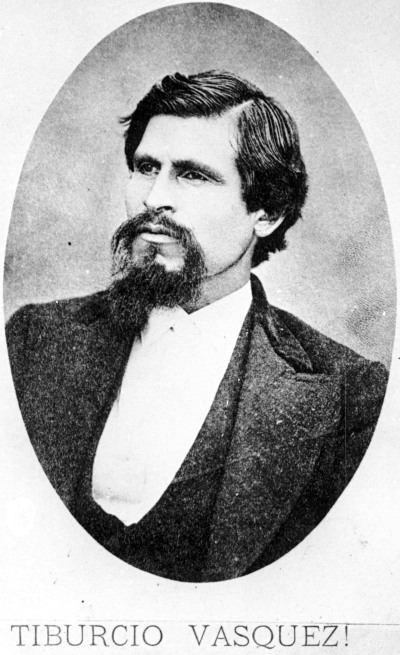
and outlaws who held out in mountain hide-a-ways, inlcuding one who reportedly
hid in Laurel Canyon. His name was Tiburcio Vasques, a stage robber, a
murderer and a romantic symbol of resistance to the American annexation
of California.
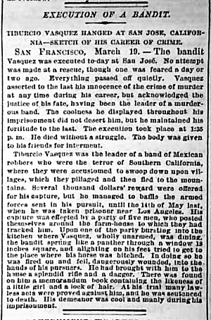
A New York Tribune story on the hanging of romantic bandit, Tiburcio
Vasquez in 1875.
Bandits
like Vasques and "other Mexican residents resisted the new Anglo
powers by resorting to social banditry against the Gringos. In 1856, Juan
Flores threatened the southland with a full-scale Mexican revolt. He was
hanged in Los Angeles in front of 3,000 spectators. Tiburcio Vasques,
a legend in his own time among the Mexican population for his daring feats
against the Anglos", was finally caught at a sympathizer's ranch
house at Kings Road and Santa Monica Boulevard in the area that is now
West Hollywood. Before he was hung in San Jose, Vasquez delivered the
following statement: "A spirit of hatred and revenge took possession
of me. I had numerous fights in defense of what I believed to be my rights
and those of my countrymen. I believed we were unjustly deprived of the
social rights that belonged to us."
Early Development
Things eventually calmed down, and the original Spanish ranchos were subdivided
in the 1880's; and, in 1886, the town of Hollywood was established by
H.H. Wilcox. (His wife gave the town its name.) This began the irreversible
shift from agriculture to residences to business. "(Wilcox) planned
the streets, paved Prospect Avenue (part of which still exists in Los
Feliz but most of what is now Hollywood Boulevard) for the main street
and was selling large residential lots to the more wealthy pilgrims coming
to sunny California. Hollywood quickly became a prosperous community.
Prospect Avenue was filled with Victorian, Queen Anne, and Mission Revival
homes. Hollywood incorporated in 1903. In 1910 it became a part of the
city of Los Angeles, largely over issues of water supply."
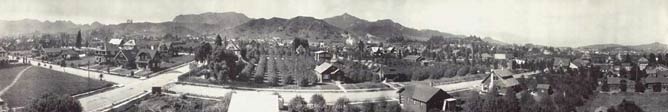
View of early Hollywood looking north toward the Santa Monica Mountains.
The late 1800's marked a period of great immigration from the crowded
and polluted cities of the East. Visions of Arcadia were being sold to
Easterners who longed for a fresh start in an unspoiled land. Developers
sought to match the Mediterranean climate with Andalusian dreamscapes
of Spanish and Moorish homes. The result was a postcard for which Laurel
Canyon provided the perfect backdrop.
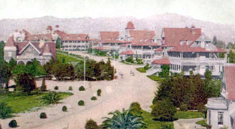
Early Hollywood as shown in this postcard of the period.
However, there was one problem: a lack of water. Stepping in to solve
this was the horse trader, geologist and oil speculator, Edward L. Doheny.
He and other land speculators bought land that they knew to be valuable
to William Mulholland, who was a self-taught hydraulic engineer and the
founder of the Department of Water and Power. Doheny's Franklin Canyon
reservoir would become the main source of water for the DWP. Other water
companies would follow, including one founded to exploit the spring-fed
steam in Laurel Canyon.
Despite all the new people and development, Laurel Canyon remained quite
rural until well into the 1900's, with just a few cabins set on large
tracts of homestead land. One of the more colorful residents of the time
was Frederick Shaw, or Crazy Shaw as he was known to neighbors. Shaw owned
several acres in the area of Hermit's Glenn, which is believed to be his
namesake. From there, he went about town trying to interest townspeople
in his visionary ideas about science and development schemes. Shaw's personality
was so odd that an attempt was made to institutionalize him, but the effort
failed.
Serious development in the canyon was set in motion by Charles Spencer
Mann, an engineer and real estate investor. (This is not the same Charles
Mann who founded Mann Realty at Kirkwood and Laurel Canyon Boulevard -
just an odd coincidence of history.) Mann and his water company partners
bought property along Laurel Canyon Boulevard and up in the hills. He
installed the nation's first trackless trolley in 1913 to bring residents
and prospective buyers from the streetcar line at Sunset Boulevard to
a roadhouse tavern at Lookout Mountain Avenue. The fare was 10 cents.
He named his first development of verdant hillsides and running streams,
Bungalow Land. Some critics of the time said he loved it so much, he nearly
ruined it. The log cabin road house, that had a bowling alley in the basement,
was later bought by silent film star Tom Mix. One of the last residents
to occupy the cabin before it burned in the 1970's was Frank Zappa.
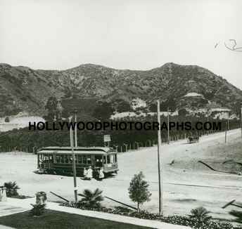

Streetcar line at Sunset and Laurel Canyon, and the trackless trolley
on Laurel Canyon Boulevard, around 1913.
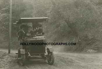
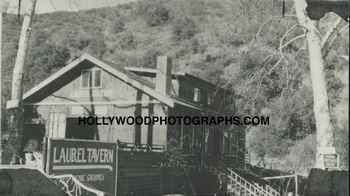
A Stanley Steamer negotiating the dirt Laurel Canyon Boulevard on
the way to the Laurel
Tavern, circa 1916. The site of the tavern later became the home of Tom
Mix and still later, Frank Zappa.
The trackless trolley was retired after only five years as canyon transportation
was replaced by Stanley Steamers and then by the automobile. With cars
came paved roads that grew throughout the sub-divided canyon properties.
And to further increase interest in his land, Charles Mann built a lavish
inn at the crest of Lookout Mountain.
From a local newspaper of 1912, "Alfred F. Priest has prepared sketches
for a large three-story and basement hotel building to be erected in Laurel
Canyon by the Canyon Castle Corporation, Chas. Mann and Sam S. Porter.
The building is designed in the form of a letter U with extreme dimensions
200x150 feet. The basement will contain a large ballroom, card room, billard
room, tonsorial parlor, laundry, storage and boiler. In the first story
there will be banquet and dining rooms, office and main lobby, ladies
parlors and kitchen department. The upper stories will contain seventy
guest rooms with a dressing room and private bathroom for each. The interior
finnish will be Oregon pine and white enamel with mahogony doors. There
will be two passenger elevators, steam heat, plumbing, electric wiring,
ice and refrigerating plant, vacuum cleaning system, etc. There will also
be a garage, stable, tennis courts, golf links, etc. The cost is to be
from $86,000 to $100,000, and it is expected that work will be started
soon."
A popular myth is that the grounds around the Inn were stocked with exotic
animals for hunting, but this has not been verified. The Inn burned down
in the 1923, and the site was rebuilt with a home for actor Lew Ayres
- the original Dr. Kildare.
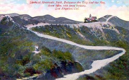
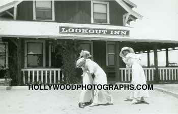
The Lookout Inn, at the top of Lookout Mountain at Appian Way, had a commanding
view of the LA Basin, the Pacific Ocean and the San Gabriels. On the right,
guests of the Lookout Inn playing to the camera in 1915.
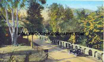
A postcard showing Laurel Canyon Boulevard at Lookout Mountain Road in
the 1920's. The property on the right was developed by Harry Houdini,
and the one on the left was owned by Tom Mix. His log cabin, which was
the site of many rock star gatherings in the 1970's, can be seen just
past the tree on the left.
The history section is continued in 20th Century
Canyon History.
©
2003 Richard Seireeni, reproduction by permission.
Back to the Top

|
Your Laurel Canyon Association
Emergency Information
Government Services
Geology and Climate
Early Canyon History
View From Lookout Mtn, 1906
20th Century Canyon History
Flora and Fauna
Residential Styles
Wonderland School
Recreation
Community Resources
Quality of Life Issues
What To Do: Fire
What To Do: Rain & Flood
A Blueprint For Paradise
|
|